🚀 From Google Podcasts to Moon FM in No Time: Your Hassle-Free Migration Guide
👉

This is BHS16, being aware of what weather can create over Mississippi State.

Scattered showers are likely in the middle of the week as winds slowly change to the southwest. This will bring gulf moisture into the area. Starting in the middle of the week a large ridge of high pressure will be to our north. This will allow for heat index values to reach beyond 100°F.
The podcast is finally on iTunes. Next podcast going up next week. Go to http://itunes.apple.com/us/podcast/id450339577 to subscribe.
This week will be a big change compare to last week. We will be gradually warming up throughout the week. This week should be in the low to mid 60s. Latest surface map pictured below shows an absence of a low pressure system present for Starkville this week.

Latest GFS shows that a weak disturbance will be returning to the area in the early morning hours of Wednesday. Wednesday’s forecast will be scattered showers. GFS shows no real change in the weather through next weekend. That still is a while out, so things can change.
To get the latest information go to www.twitter.com/bulldogsweather. If you want any questions answered email me at [email protected]

Detailed short term and long term forecast will be post tomorrow.
Just made a fan page on facebook.Come check it out on
https://www.facebook.com/pages/Bulldog-Weather-Wordpress/110547419021298
If you want your questions answered live, come chat on this post through irc.
http://webchat.irchighway.net/?channels=bulldogweather.wordpress.com
NAM is showing more promise for forecasting snow. Last several runs have showed a pattern of heavy snowband situated over the golden triangle area. Based on this I am predicting five to eight inches of snow for our area. Northwards towards the Memphis metro area, there will be 3-6 inches of snow. Near the I-20 corridor going southward to I-84 there will be the best possibility for ice up to a 1/2 inch. I will keep updating the forecast based on latest soundings. If the upper levels of the atmosphere are unsaturated, the snowfall values will go down. If a warm layer develops at the mid levels we could experience ice.

estimated snow accumulations
Our weather will become cooler next week with an airmass coming from Canada. Before we get to the long-term, lets look at what will happen this week. We have the potential of seeing winter precipitation. This precipitation will be determined by the track of the low. the current GFS model shows the low tracking across the coast. On Sunday we have around a 20% chance of freezing precipitation. As of right now, slight to no snow accumulation with the main hazard being freezing precipitation. When it gets closer, I will update the website and twitter feed.
In the long-term an airmass from Canada will push south by mid-week, latest guidance models show that this could be the coldest conditions this season. Forecast will go up later this week.
Have any questions? email me at [email protected]
11 p.m. eastern
Hurricane Earl has Maximum winds of 135 mph. Moving at 14 mph WNW . East coast watch for this system even though it may not hit you, its wind field is quite large. Earl is producing Tropical Storm force wind out to 200 miles from the center.
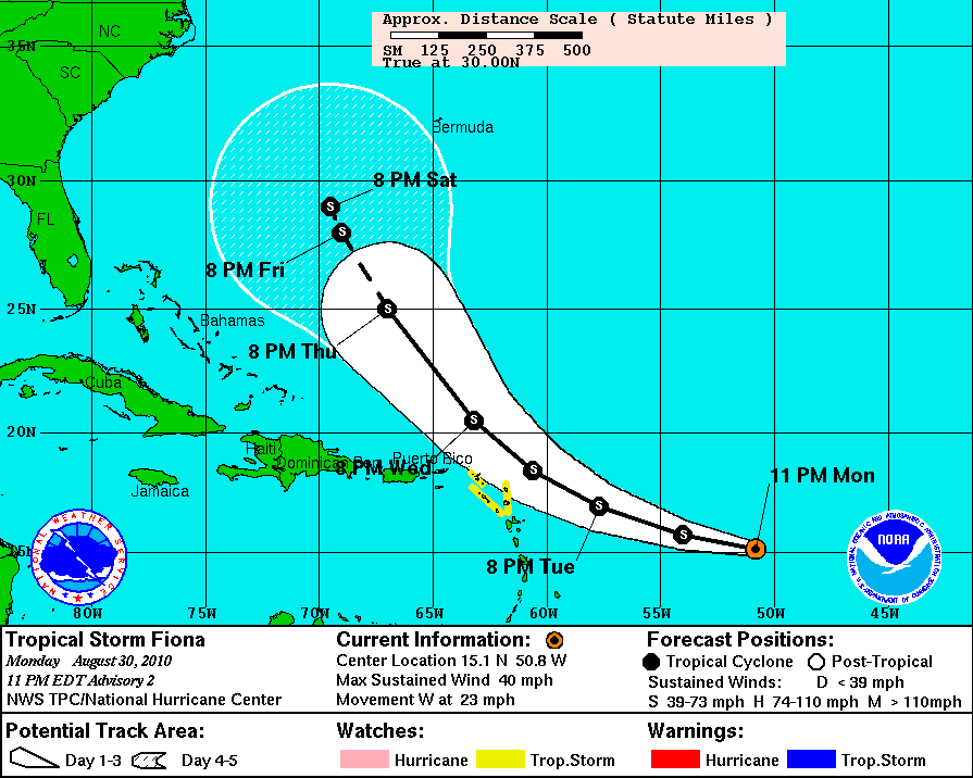
Another tropical storm named Fiona has formed and as of right now its path is on course to hit the east coast. Maximum winds of 40 mph and is moving at 23 mph W.
Weather forecast will be up on the site tomorrow afternoon.
Your feedback is valuable to us. Should you encounter any bugs, glitches, lack of functionality or other problems, please email us on [email protected] or join Moon.FM Telegram Group where you can talk directly to the dev team who are happy to answer any queries.